
The Marshall Fire: Driving Around the Map
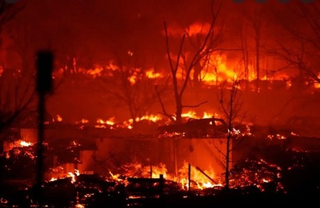
If you were watching TV on December 30, you may have seen this:
If you checked back the next morning you could have seen this:

The Marshall fire, driven by Category 2 hurricane-force winds, burned more than 6,000 acres, destroyed 1,000+ buildings (homes + commercial), cost well over a half-billion dollars in damages, and – miraculously – only killed two people.
Yesterday, finally, I drove up to look around. Here, in no particular order, are some observations.
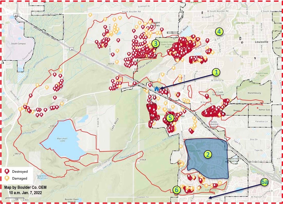
1: Close to home. We often use the phrase. In this case, though…
See that little blue house icon the green number one is pointing to? I lived there for a year when I moved back to Colorado in 2007 or so. It’s untouched. But the red to the right shows the burned homes between it and the Home Depot. The one next door is where my landlord Tom lived.
This was the biggest shock of the day. Based on what I had seen and heard, I thought all the houses along that road were okay.
I don’t know if Tom sold everything or if these were still his properties. He was a nice guy, and I hope he’s okay.
2: Rock Creek. I know wildfires can be capricious, and as you can tell by looking at this map, this one was no exception. The big blue area noted by the number two is a huge residential subdivision. My good friend Anders and his family used to live in there, and for a while our company offices were in the basement. When I look at how the fire was behaving, I have no idea how it avoided that section.
3: Davidson Mesa. I used to take my dog walking in the park on Davidson Mesa every morning. It’s hard to see that all those houses down the hill on the west side are gone. Likewise, everything across McCaslin to the east and along the northern side of Centennial Parkway…
I remember watching the fire coverage on TV and trying to visualize where some of this activity was taking place. But I haven’t lived there in a while, and almost none of the reporters had any clue where they were or what they were looking at. So yesterday was the first chance I had to really get the map straight in my mind.
4: By the skin of our teeth. I think one of my biggest surprises yesterday was realizing how much didn’t burn. I’m sure the people who own houses further east along Via Appia were terrified. Had the wind not died down there was a lot more waiting to be burned. And had it jumped S. Boulder Rd. to the north…
5: Old Superior. The fire was disaster for … well, just about everybody. But it was great news for the developers who have been trying to buy out the old Superior neighborhood for years. There was a core of old, run-down historic homes owned by people who liked it that way and who were. Not. Gonna. Sell. Meanwhile, progress built up around them.
The fight may not be over, but the holdouts have certainly lost a lot of leverage.
6: WTF? No, seriously. Look towards the bottom where the number six is. Look at that small line of fires along Coalton Road. Then look at all the real estate to the north that’s untouched. I’m not a fire expert or a weather expert. I know these things behave strangely.
(My first thought was that I could imagine a suspicious fire marshall looking at the map, scratching his head, and going out to the west end of that line and snooping around for signs of opportunistic arson.)
I used the phrase earlier – close to home. The reason we were watching this portion of the area so closely is the the spot indicated by 6a. That’s where my girlfriend’s best friend lives. That the fire didn’t jump Coalton was a massive relief at my house (also hers, I imagine).
She can look out the back window and see ruins. She can see just how close the inferno got. And she’s grateful for the fire crews that lined their trucks up along the road and, in a scene a little bit like Gandalf facing down the Balrog, said to the fire you shall not pass.
My people are mostly okay, although I now know there a thing called survivor’s guilt, and I imagine there are thousands of cases in the area now.
